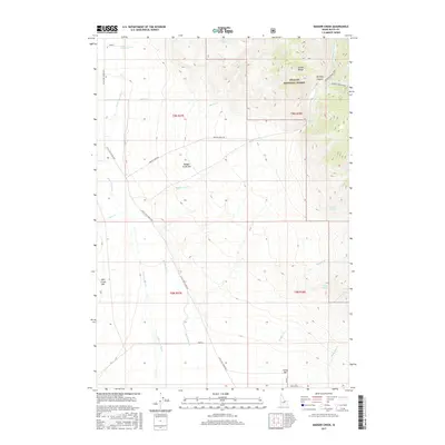
2017 Map of Badger Creek
USGS Topo · Published 2017About this map
The Lemhi Range dominates the northeastern landscape of this Butte County region, where the steep terrain of the Challis National Forest meets the alluvial plains of the Little Lost River valley. This 2017 study illustrates the remote mountain-to-valley transition, marked by ephemeral water sources like Coyote Spring and Fowler Springs. The high country is defined by features such as Bunting Canyon and the Badger Creek Mine, which sits at the head of the Badger Creek Trail. Down in the valley, the Little Lost River Hwy serves as the primary artery, connecting several bar-type settlements along the river's edge, including Badger Creek Bar and Sunny Bar. The drainage patterns of Big Spring Cr and Boulder Cr reveal how water moves from the high peaks toward the agricultural flats below.
Find a feature on this map
27 named features on this map. Tap any name to fly to it.
Don’t see what you’re looking for? This feature index may not catch every label — zoom into the map to look around manually.
Map Details
Editions of this 2017 Badger Creek Map
This is the sole edition of this map. No revisions or reprints were ever made.
Other maps of this area

1955 · Dubois
USGS Topo · 1:250,000

1955 · Idaho Falls
USGS Topo · 1:250,000

1957 · Diamond Peak
USGS Topo · 1:62,500

1957 · Hawley Mountain
USGS Topo · 1:62,500

1958 · Dubois
USGS Topo · 1:250,000

1958 · Idaho Falls
USGS Topo · 1:250,000

1969 · Howe NW
USGS Topo · 1:24,000

1969 · Howe NE
USGS Topo · 1:24,000

1969 · Sunset Peak
USGS Topo · 1:24,000
1987 · Fallert Springs
USGS Topo · 1:24,000