
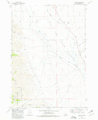
1969 Map of Howe NW
USGS Topo · Published 1973About this map
Challis National Forest defines the western edge of this topographic study, where steep mountain drainages transition into the broad Little Lost River Valley. The landscape is shaped by the desert-mountain hydrology typical of this Idaho region, as water flows from rugged landmarks like Buck Canyon and Cedarville Canyon toward the valley floor. The map records a sparse network of infrastructure in the late 1960s, consisting primarily of isolated wells and intermittent water sources such as Big Spring Creek and Uncle Ike Creek. This environment supported a ranching and resource-extraction economy, evidenced by the presence of a Gravel Pit and numerous fine red dashed lines indicating livestock fence lines that cross the Little Lost River.
Find a feature on this map
20 named features on this map. Tap any name to fly to it.
Don’t see what you’re looking for? This feature index may not catch every label — zoom into the map to look around manually.
Map Details
Editions of this 1969 Howe NW Map
2 editions found
Other maps of this area

1955 · Dubois
USGS Topo · 1:250,000

1955 · Idaho Falls
USGS Topo · 1:250,000

1957 · Diamond Peak
USGS Topo · 1:62,500

1957 · Hawley Mountain
USGS Topo · 1:62,500

1958 · Dubois
USGS Topo · 1:250,000

1958 · Idaho Falls
USGS Topo · 1:250,000

1969 · Arco Pass
USGS Topo · 1:24,000

1969 · Ramshorn Canyon
USGS Topo · 1:24,000

1969 · Howe
USGS Topo · 1:24,000

1969 · Howe NE
USGS Topo · 1:24,000