
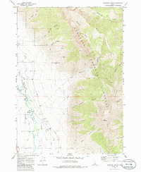
1969 Map of Ramshorn Canyon
USGS Topo · Published 1973About this map
The Big Lost River Valley forms a broad agricultural corridor at the base of the Lost River Range, where early water management infrastructure was essential for settlement. The valley floor is crisscrossed by irrigation features like the Moore Diversion and various segments simply labeled Ditch, which carry water from the Big Lost River to the surrounding fields. Local history is anchored by the Pioneer Cem near the riverbanks, marking the presence of early inhabitants who worked this land before the era of modern utility infrastructure, such as the Substation and Storage Bin now seen along Moore Road.
Find a feature on this map
32 named features on this map. Tap any name to fly to it.
Don’t see what you’re looking for? This feature index may not catch every label — zoom into the map to look around manually.
Map Details
Editions of this 1969 Ramshorn Canyon Map
2 editions found
Other maps of this area

1955 · Idaho Falls
USGS Topo · 1:250,000

1958 · Idaho Falls
USGS Topo · 1:250,000

1969 · Darlington
USGS Topo · 1:24,000

1969 · Arco Pass
USGS Topo · 1:24,000

1969 · Howe NW
USGS Topo · 1:24,000

1969 · Sunset Peak
USGS Topo · 1:24,000
1969 · Methodist Creek
USGS Topo · 1:24,000

1972 · Arco North
USGS Topo · 1:24,000

1972 · Arco Hills
USGS Topo · 1:24,000

1972 · Appendicitis Hill
USGS Topo · 1:24,000