
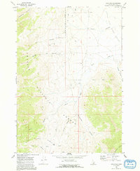
1969 Map of Arco Pass
USGS Topo · Published 1973About this map
The Lost River Range dominates this late-1960s topographic study, where the high-altitude terrain of the Challis National Forest meets the northern extent of the Little Lost River Valley. The mapping focuses on a network of steep drainages, including Cedarville Canyon and Taylor Canyon, that descend from the peaks toward the valley floor. A strategic crossing is marked at Arco Pass, where a Jeep Trail provides the primary means of navigating the rugged corridor between the ranges. This map captures the region’s character as a managed wilderness, defined by its water sources such as Hurst Creek and numerous unnamed springs. The distribution of these springs and the intricate systems of Horsethief Canyon and Corral Canyon illustrate the land's reliance on seasonal runoff and localized hydrology in this corner of Butte County.
Find a feature on this map
17 named features on this map. Tap any name to fly to it.
Don’t see what you’re looking for? This feature index may not catch every label — zoom into the map to look around manually.
Map Details
Editions of this 1969 Arco Pass Map
2 editions found
Other maps of this area

1955 · Idaho Falls
USGS Topo · 1:250,000

1958 · Idaho Falls
USGS Topo · 1:250,000

1969 · Ramshorn Canyon
USGS Topo · 1:24,000

1969 · Howe
USGS Topo · 1:24,000

1969 · Howe NW
USGS Topo · 1:24,000

1969 · Howe NE
USGS Topo · 1:24,000

1969 · Sunset Peak
USGS Topo · 1:24,000

1972 · Arco North
USGS Topo · 1:24,000

1972 · Howe Peak
USGS Topo · 1:24,000

1972 · Arco Hills
USGS Topo · 1:24,000