
1972 Map of Howe Peak
USGS Topo · Published 1976About this map
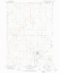
Howe Peak anchors the eastern edge of the Lost River Range in this early 1970s survey, marking a stark division between wilderness and government territory. To the west, the Challis National Forest protects high-elevation terrain carved by Sixmile Canyon and Eightmile Canyon. To the east and south, the landscape shifts abruptly into the high-desert plains of the National Reactor Testing Station. This restricted zone includes Deadman Flat and the small site at Grafton. The map illustrates the specialized land use of the era, where remote Idaho canyons meet the scientific frontier. Numerous Borrow Pits and a network of Jeep Trails suggest ongoing industrial and maintenance activity supporting the nearby facilities. Local history researchers will find the specific Restricted boundaries and infrastructure, such as the Radio Facility, helpful for understanding the footprint of federal energy research in Butte County.
Find a feature on this map
17 named features on this map. Tap any name to fly to it.
Don’t see what you’re looking for? This feature index may not catch every label — zoom into the map to look around manually.
Map Details
Editions of this 1972 Howe Peak Map
This is the sole edition of this map. No revisions or reprints were ever made.
Other maps of this area

1955 · Idaho Falls
USGS Topo · 1:250,000

1958 · Idaho Falls
USGS Topo · 1:250,000

1969 · Arco Pass
USGS Topo · 1:24,000

1969 · Little Lost River Sinks
USGS Topo · 1:24,000

1969 · Howe
USGS Topo · 1:24,000

1972 · Arco Hills SE
USGS Topo · 1:24,000

1972 · Butte City
USGS Topo · 1:24,000

1972 · Arco Hills
USGS Topo · 1:24,000

1973 · Circular Butte 3 SW
USGS Topo · 1:24,000
1973 · Circular Butte 3 NW
USGS Topo · 1:24,000