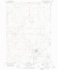
1973 Map of Circular Butte 3 NW
USGS Topo · Published 1977About this map
The Idaho National Engineering Laboratory dominates this high-desert landscape in Butte County during the early 1970s. This specialized federal footprint is defined by industrial and military infrastructure, most notably the US Naval Reactors Facility. The map captures a high degree of technical detail, including the US Government Railroad and the primary transit artery of Lincoln Boulevard. While the eastern portion of the sheet shows the winding course of the Big Lost River, much of the interior is characterized by the utility of the site, marked by numerous Borrow Pits, Sewage Disposal Ponds, and an Industrial Waste Pond. This survey reflects the height of Cold War-era energy and naval research operations in the Idaho desert.
Find a feature on this map
10 named features on this map. Tap any name to fly to it.
Don’t see what you’re looking for? This feature index may not catch every label — zoom into the map to look around manually.
Map Details
Editions of this 1973 Circular Butte 3 NW Map
2 editions found
Other maps of this area

1955 · Idaho Falls
USGS Topo · 1:250,000

1958 · Idaho Falls
USGS Topo · 1:250,000

1969 · Little Lost River Sinks
USGS Topo · 1:24,000

1969 · Howe
USGS Topo · 1:24,000

1969 · Big Lost River Sinks
USGS Topo · 1:24,000

1972 · Arco Hills SE
USGS Topo · 1:24,000

1972 · Howe Peak
USGS Topo · 1:24,000

1973 · Circular Butte 3 NE
USGS Topo · 1:24,000

1973 · Circular Butte 3 SW
USGS Topo · 1:24,000

1973 · Circular Butte 3 SE
USGS Topo · 1:24,000