
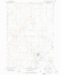
1969 Map of Little Lost River Sinks
USGS Topo · Published 1973About this map
The Little Lost River Valley reveals a stark hydraulic landscape where surface waters vanish into the eastern Idaho desert. This 1969 field-checked survey focuses on the geological terminus of two major drainage systems: the Little Lost River Sinks and the Big Lost River Sinks. The terrain is characterized by a vast Depression and the rugged southern slopes of the Lemhi Range, which rise sharply from the valley floor. Human activity is sparse and functional, centered on the National Reactor Testing Station that occupies the southern portion of the quadrangle. Aside from the atomic research boundary, the map records the former location of Berenice, along with scattered infrastructure including several Gravel Pits, a Storage Bin, and a network of wells essential for survival in this arid terminal basin.
Find a feature on this map
14 named features on this map. Tap any name to fly to it.
Don’t see what you’re looking for? This feature index may not catch every label — zoom into the map to look around manually.
Map Details
Editions of this 1969 Little Lost River Sinks Map
This is the sole edition of this map. No revisions or reprints were ever made.
Other maps of this area

1955 · Idaho Falls
USGS Topo · 1:250,000

1958 · Idaho Falls
USGS Topo · 1:250,000

1969 · Richard Butte
USGS Topo · 1:24,000

1969 · Tyler Peak
USGS Topo · 1:24,000

1969 · Howe
USGS Topo · 1:24,000

1969 · Howe NE
USGS Topo · 1:24,000

1969 · Big Lost River Sinks
USGS Topo · 1:24,000

1972 · Howe Peak
USGS Topo · 1:24,000

1973 · Circular Butte 3 NE
USGS Topo · 1:24,000
1973 · Circular Butte 3 NW
USGS Topo · 1:24,000