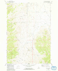
1969 Map of Arco Pass
USGS Topo · Published 1992About this map
Challis National Forest dominates this high-altitude landscape in the Lost River Range, where the terrain transitions sharply into the Little Lost River Valley. Surveyed in the late 1960s, the map reveals a network of canyons including Cedarville Canyon, Taylor Canyon, and Horsethief Canyon that carve through the mountain slopes. The namesake Arco Pass serves as a critical geographic notch in the range, connected by primitive 4WD tracks that follow natural contours. Vital water sources like Brier Springs and Hurst Creek are mapped in detail, showing the scarce but essential riparian points in this arid environment. The spatial arrangement of these springs and canyons highlights the historical routes used to navigate the rugged passage between the mountain peaks and the broad valley floor.
Find a feature on this map
16 named features on this map. Tap any name to fly to it.
Don’t see what you’re looking for? This feature index may not catch every label — zoom into the map to look around manually.
Map Details
Editions of this 1969 Arco Pass Map
2 editions found
Other maps of this area

1955 · Idaho Falls
USGS Topo · 1:250,000

1958 · Idaho Falls
USGS Topo · 1:250,000

1969 · Arco Pass
USGS Topo · 1:24,000

1969 · Ramshorn Canyon
USGS Topo · 1:24,000

1969 · Howe
USGS Topo · 1:24,000

1969 · Howe NW
USGS Topo · 1:24,000

1969 · Howe NE
USGS Topo · 1:24,000

1969 · Sunset Peak
USGS Topo · 1:24,000

1972 · Arco North
USGS Topo · 1:24,000

1972 · Howe Peak
USGS Topo · 1:24,000