
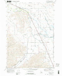
1969 Map of Darlington
USGS Topo · Published 1973About this map
The Big Lost River Valley serves as a vital corridor for irrigation and transit in this late-1960s survey of Custer and Butte counties. Small agricultural settlements like Leslie and Darlington are connected by the Union Pacific Railroad and a sophisticated network of water management features, including the Union Ditch, Blaine Canal, and Moore Canal. This infrastructure highlights the intensive effort to manage the Big Lost River as it passes through the Darlington Sinks, utilizing engineering works such as a Siphon, Flume, and Chute to direct water across the arid landscape.
Find a feature on this map
31 named features on this map. Tap any name to fly to it.
Don’t see what you’re looking for? This feature index may not catch every label — zoom into the map to look around manually.
Map Details
Editions of this 1969 Darlington Map
2 editions found
Other maps of this area

1935 · MacKay
USGS Topo · 1:96,000

1940 · Mackay
USGS Topo · 1:62,500

1955 · Idaho Falls
USGS Topo · 1:250,000

1958 · Idaho Falls
USGS Topo · 1:250,000

1960 · Grouse
USGS Topo · 1:62,500

1960 · Mackay
USGS Topo · 1:62,500

1969 · Ramshorn Canyon
USGS Topo · 1:24,000

1969 · Sunset Peak
USGS Topo · 1:24,000
1969 · Methodist Creek
USGS Topo · 1:24,000

1972 · Arco North
USGS Topo · 1:24,000