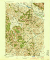
1940 Map of Mackay
USGS Topo · Published 1940About this map
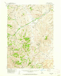
Mackay stands as the primary hub along the Big Lost River in this pre-war survey, where the valley's agricultural life meets the industrial infrastructure of the Union Pacific railroad. The landscape is defined by extensive irrigation networks, including the Swauger Ditch, Burnett Ditch, and Union Ditch, which redirect water from the Mackay Reservoir to the surrounding foothills. To the west and south, the map reveals the hardscrabble mining and ranching character of the White Knob Mountains and Pioneer Mountains. Remote outposts such as Rosenkrance Ranch and the Leadbelt Mine are connected by a web of mountain trails and forest ranger stations like the Copper Basin Ranger Sta. This map captures a transition period in Idaho's history, where established settlements like Houston and Martin served as vital nodes for local families, supported by rural institutions such as Barton Sch and the Methodist Church.
Find a feature on this map
92 named features on this map. Tap any name to fly to it.
Don’t see what you’re looking for? This feature index may not catch every label — zoom into the map to look around manually.
Map Details
Editions of this 1940 Mackay Map
2 editions found
Other maps of this area

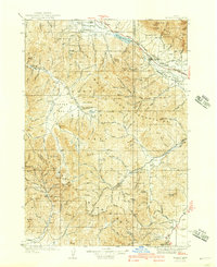
1935 · MacKay
USGS Topo · 1:96,000

1935 · Borah Peak
USGS Topo · 1:125,000

1938 · Borah Peak
USGS Topo · 1:125,000

1955 · Dubois
USGS Topo · 1:250,000

1955 · Idaho Falls
USGS Topo · 1:250,000
1957 · Hawley Mountain
USGS Topo · 1:62,500

1958 · Dubois
USGS Topo · 1:250,000

1958 · Idaho Falls
USGS Topo · 1:250,000
1960 · Muldoon Canyon
USGS Topo · 1:62,500
1960 · Grouse
USGS Topo · 1:62,500