
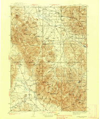
1938 Map of Borah Peak
USGS Topo · Published 1938About this map
Borah Peak and the high elevations of the Lost River Range dominate this 1930s landscape, providing a detailed look at the cattle ranching and early forest management infrastructure in Custer County. The map documents the high-altitude settlement pattern where family-run operations like Swauger Ranch, Carlson Ranch, and Jarvis Ranch are situated near vital water sources such as Thousand Springs and the Pahsimeroi River. This era shows a network of remote outposts, including the Pahsimeroi Ranger Station and Mahogany Ranger Station, which were essential for managing the surrounding national forest lands.
Find a feature on this map
73 named features on this map. Tap any name to fly to it.
Don’t see what you’re looking for? This feature index may not catch every label — zoom into the map to look around manually.
Map Details
Editions of this 1938 Borah Peak Map
2 editions found
Other maps of this area

1895 · Hailey
USGS Topo · 1:125,000

1897 · Hailey
USGS Topo · 1:125,000

1929 · Bayhorse
USGS Topo · 1:125,000

1935 · MacKay
USGS Topo · 1:96,000

1935 · Borah Peak
USGS Topo · 1:125,000
1940 · Mackay
USGS Topo · 1:62,500

1955 · Dubois
USGS Topo · 1:250,000

1955 · Idaho Falls
USGS Topo · 1:250,000

1955 · Hailey
USGS Topo · 1:250,000
1956 · Leadore
USGS Topo · 1:62,500