
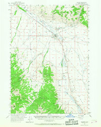
1956 Map of Leadore
USGS Topo · Published 1958About this map
Leadore sits at the junction of mountain and valley, serving as a hub for the high-country economy of Lemhi County in the mid-1950s. The settlement pattern is defined by the Lemhi River and its tributaries, including Eighteenmile Creek and Texas Creek, which drain the massive slopes of the Salmon National Forest. High-altitude landmarks like Sheephorn Peak and Junction Peak overlook a landscape carved by mining and transport, where prospects, shafts, and gravel pits dot the hillsides. The transportation history of the region is clearly visible through the Union Pacific Railroad tracks and an Old Railroad Grade that trends southward toward the high basin. Local history is anchored by the McRea Cem and the Leadore Ranger Sta, while numerous backcountry trails like the Foot Trail near Purcell Spring indicate the era's reliance on rugged access routes for forest management and mineral exploration.
Find a feature on this map
74 named features on this map. Tap any name to fly to it.
Don’t see what you’re looking for? This feature index may not catch every label — zoom into the map to look around manually.
Map Details
Editions of this 1956 Leadore Map
2 editions found
Other maps of this area

1935 · Borah Peak
USGS Topo · 1:125,000

1938 · Borah Peak
USGS Topo · 1:125,000

1955 · Dubois
USGS Topo · 1:250,000

1956 · Morrison Lake
USGS Topo · 1:62,500

1956 · Patterson
USGS Topo · 1:62,500

1956 · Donkey Hills
USGS Topo · 1:62,500

1956 · Nicholia
USGS Topo · 1:62,500

1956 · Lemhi
USGS Topo · 1:62,500

1957 · Gilmore
USGS Topo · 1:62,500

1958 · Dubois
USGS Topo · 1:250,000