
1929 Map of Bayhorse
USGS Topo · Published 1961About this map
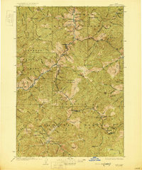
Bayhorse and Clayton serve as the primary human anchors in this rugged section of central Idaho, surveyed between 1927 and 1929. The region’s economic identity is defined by significant high-elevation mining operations, including the Ramshorn Mine and Beardsley Mine located near the canyon walls of Bayhorse Creek. The rugged geography of the Challis National Forest is punctuated by deep basins and peaks such as Bald Mtn and Ramshorn Mtn.
Find a feature on this map
126 named features on this map. Tap any name to fly to it.
Don’t see what you’re looking for? This feature index may not catch every label — zoom into the map to look around manually.
Map Details
Editions of this 1929 Bayhorse Map
This is the sole edition of this map. No revisions or reprints were ever made.
Other maps of this area

1895 · Hailey
USGS Topo · 1:125,000

1897 · Hailey
USGS Topo · 1:125,000

1900 · Sawtooth
USGS Topo · 1:125,000

1919 · Custer
USGS Topo · 1:125,000

1922 · Custer
USGS Topo · 1:125,000
1930 · Casto
USGS Topo · 1:125,000

1935 · MacKay
USGS Topo · 1:96,000

1935 · Borah Peak
USGS Topo · 1:125,000

1938 · Borah Peak
USGS Topo · 1:125,000

1955 · Dubois
USGS Topo · 1:250,000