
1919 Map of Custer
USGS Topo · Published 1964About this map
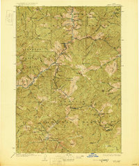
Mining and mountain hydrology dominate this survey of the Salmon River headwaters and the high peaks of the Sawtooth Mountains. The Yankee Fork serves as a corridor of early industrial activity, linking the settlements of Custer and Bonanza near the Sunbeam Mine. Along the main river, the Sunbeam Dam and the Fisher Mill represent the infrastructure required to power and process the region's mineral wealth.
Find a feature on this map
116 named features on this map. Tap any name to fly to it.
Don’t see what you’re looking for? This feature index may not catch every label — zoom into the map to look around manually.
Map Details
Editions of this 1919 Custer Map
This is the sole edition of this map. No revisions or reprints were ever made.
Other maps of this area

1891 · Bear Valley
USGS Topo · 1:125,000

1893 · Bear Valley
USGS Topo · 1:125,000

1894 · Rocky Bar
USGS Topo · 1:125,000

1895 · Hailey
USGS Topo · 1:125,000

1897 · Hailey
USGS Topo · 1:125,000

1900 · Sawtooth
USGS Topo · 1:125,000

1922 · Custer
USGS Topo · 1:125,000

1929 · Bayhorse
USGS Topo · 1:125,000
1930 · Casto
USGS Topo · 1:125,000

1955 · Hailey
USGS Topo · 1:250,000