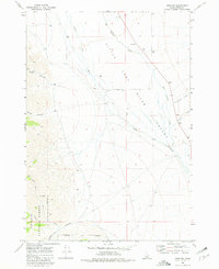
1969 Map of Howe NW
USGS Topo · Published 1981About this map
Little Lost River Valley forms the central focus of this 1969 field survey, showcasing a landscape defined by its vital water sources and varied relief. The Little Lost River winds through the basin, joined by tributaries like Big Spring Creek, Uncle Ike Creek, and North Creek. These watercourses were essential to the development of the region's ranching and agricultural life. To the west, the topography rises sharply into the eastern reaches of the Challis National Forest.
Find a feature on this map
17 named features on this map. Tap any name to fly to it.
Don’t see what you’re looking for? This feature index may not catch every label — zoom into the map to look around manually.
Map Details
Editions of this 1969 Howe NW Map
2 editions found
Other maps of this area

1955 · Dubois
USGS Topo · 1:250,000

1955 · Idaho Falls
USGS Topo · 1:250,000

1957 · Diamond Peak
USGS Topo · 1:62,500

1957 · Hawley Mountain
USGS Topo · 1:62,500

1958 · Dubois
USGS Topo · 1:250,000

1958 · Idaho Falls
USGS Topo · 1:250,000

1969 · Arco Pass
USGS Topo · 1:24,000

1969 · Ramshorn Canyon
USGS Topo · 1:24,000

1969 · Howe
USGS Topo · 1:24,000

1969 · Howe NW
USGS Topo · 1:24,000