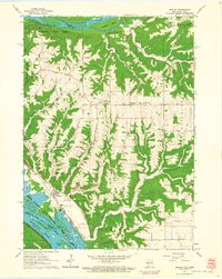
1962 Map of Bagley
USGS Topo · Published 1964About this map
The Wisconsin River meets the Mississippi River in this detailed 1962 field-checked study of Grant County. The landscape is defined by the sharp transition from the elevated Wyalusing Military Ridge down to the complex river bottoms and islands. The village of Bagley sits at the base of the bluffs, positioned between the river sloughs and the steep drainages of Glass Hollow and Read Hollow.
Find a feature on this map
33 named features on this map. Tap any name to fly to it.
Don’t see what you’re looking for? This feature index may not catch every label — zoom into the map to look around manually.
Map Details
Editions of this 1962 Bagley Map
This is the sole edition of this map. No revisions or reprints were ever made.
Other maps of this area

1900 · Lancaster
USGS Topo · 1:125,000

1902 · Elkader
USGS Topo · 1:125,000

1903 · Waukon
USGS Topo · 1:125,000

1904 · Lancaster
USGS Topo · 1:125,000

1908 · Lancaster
USGS Topo · 1:125,000

1926 · Wauzeka
USGS Topo · 1:62,500

1929 · Prairie Du Chien
USGS Topo · 1:62,500

1932 · Prairie Du Chien
USGS Topo · 1:62,500

1958 · La Crosse
USGS Topo · 1:250,000

1959 · Dubuque
USGS Topo · 1:250,000