
1900 Map of Lancaster
USGS Topo · Published 1900About this map
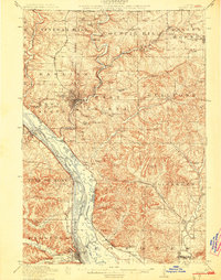
Lancaster serves as the focal point of this turn-of-the-century landscape, where the deeply dissected plateau of Grant County meets the broad corridor of the Mississippi River. The map captures a complex network of river-bottom commerce and upland agricultural settlements just before the era of modern road development. Notable river towns like Cassville and Potosi are shown in relation to the heavy rail presence of the Chicago Burlington and Northern R.R. and the Chicago Milwaukee and Paul R.R., which hugged the shoreline and navigated the steep bluffs.
Find a feature on this map
135 named features on this map. Tap any name to fly to it.
Don’t see what you’re looking for? This feature index may not catch every label — zoom into the map to look around manually.
Map Details
Editions of this 1900 Lancaster Map
This is the sole edition of this map. No revisions or reprints were ever made.
Other maps of this area

1900 · Anamosa
USGS Topo · 1:125,000

1901 · Peosta
USGS Topo · 1:125,000

1902 · Mineral Point
USGS Topo · 1:125,000

1902 · Elkader
USGS Topo · 1:125,000

1903 · Waukon
USGS Topo · 1:125,000

1904 · Lancaster
USGS Topo · 1:125,000

1905 · Richland Center
USGS Topo · 1:125,000

1908 · Lancaster
USGS Topo · 1:125,000

1911 · Galena
USGS Topo · 1:62,500
1913 · Galena
USGS Topo · 1:62,500