
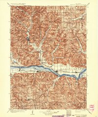
1905 Map of Richland Center
USGS Topo · Published 1905About this map
The Pine River and its numerous tributaries, including Willow Creek and Horse Creek, define the complex topography of this Wisconsin region at the beginning of the twentieth century. Richland Center serves as the central hub, connected to the south by the Richland Center Branch of the railroad. The southern portion of the map is dominated by the broad valley of the Wisconsin River, where towns such as Muscoda, Avoca, Lone Rock, and Spring Green are positioned along the Prairie du Chien Division line. Smaller nineteenth-century settlements and post offices, including Beach P.O. and Gotham P.O., illustrate a landscape of established rural communities. This survey reveals a transition from the dissected uplands near Bloom City and Rockbridge to the flat, river-dependent economies of the southern lowlands, providing a clear picture of the area's early rail and river infrastructure.
Find a feature on this map
100 named features on this map. Tap any name to fly to it.
Don’t see what you’re looking for? This feature index may not catch every label — zoom into the map to look around manually.
Map Details
Editions of this 1905 Richland Center Map
2 editions found
Other maps of this area

1900 · Lancaster
USGS Topo · 1:125,000

1901 · Denzer
USGS Topo · 1:62,500

1901 · The Dells
USGS Topo · 1:62,500

1902 · Mineral Point
USGS Topo · 1:125,000

1904 · Lancaster
USGS Topo · 1:125,000

1908 · Lancaster
USGS Topo · 1:125,000

1920 · Blue Mounds
USGS Topo · 1:62,500

1922 · Blue Mounds
USGS Topo · 1:62,500

1923 · Blanchardville
USGS Topo · 1:62,500

1926 · La Farge
USGS Topo · 1:62,500