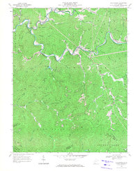
1968 Map of Baileysville
USGS Topo · Published 1971About this map
Guyandotte River and Clear Fork wind through the deeply dissected terrain of Wyoming County in this late-1960s survey. The landscape is defined by the heavy footprint of the energy industry, with numerous Gas Wells, mines, and Strip Mines scattered across the ridges. The Norfolk and Western railroad follows the riverbanks, serving the concentrated settlements of Baileysville and Brenton. Local community life is anchored by landmarks like Shands Memorial Ch and the Reedy Sch, while the presence of Tailings Ponds near Stoneville and Fanrock highlights the environmental impact of mid-century coal operations. The map also captures the topography leading toward the Wyoming and McDowell county line, where Huff Creek Mountain and Browns Creek Ridge overlook a network of family-named hollows and branches.
Find a feature on this map
61 named features on this map. Tap any name to fly to it.
Don’t see what you’re looking for? This feature index may not catch every label — zoom into the map to look around manually.
Map Details
Editions of this 1968 Baileysville Map
2 editions found
Other maps of this area

1891 · Tazewell
USGS Topo · 1:125,000

1891 · Oceana
USGS Topo · 1:125,000

1893 · Oceana
USGS Topo · 1:125,000

1895 · Tazewell
USGS Topo · 1:125,000

1897 · Tazewell
USGS Topo · 1:125,000

1898 · Oceana
USGS Topo · 1:125,000

1909 · Gilbert
USGS Topo · 1:48,000

1910 · Pineville
USGS Topo · 1:48,000

1910 · Iaeger
USGS Topo · 1:48,000

1912 · Gilbert
USGS Topo · 1:62,500