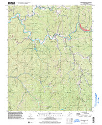
1996 Map of Baileysville
USGS Topo · Published 2003About this map
The Guyandotte River valley serves as the primary corridor for settlement and industry in this portion of Wyoming County, where the Norfolk and Western railway tracks the river's winding course. This era is defined by the massive footprint of the R D Bailey Lake and its associated State Wildlife Management Area, which transformed the northern landscape. Local life remains anchored in small coal and timber communities such as Baileysville, Brenton, and Fanrock. Genealogical interest is found in numerous scattered mountain cemeteries and local landmarks like the Sun Hill Sch and Shields Memorial Ch. The terrain is characterized by deep hollows and branches, including Moccasin Creek and Huff Creek, while the prevalence of Gas Wells and scattered Mines indicates the heavy reliance on natural resource extraction that has long shaped these Appalachian ridges.
Find a feature on this map
59 named features on this map. Tap any name to fly to it.
Don’t see what you’re looking for? This feature index may not catch every label — zoom into the map to look around manually.
Map Details
Editions of this 1996 Baileysville Map
This is the sole edition of this map. No revisions or reprints were ever made.
Other maps of this area

1891 · Tazewell
USGS Topo · 1:125,000

1891 · Oceana
USGS Topo · 1:125,000

1893 · Oceana
USGS Topo · 1:125,000

1895 · Tazewell
USGS Topo · 1:125,000

1897 · Tazewell
USGS Topo · 1:125,000

1898 · Oceana
USGS Topo · 1:125,000

1909 · Gilbert
USGS Topo · 1:48,000

1910 · Pineville
USGS Topo · 1:48,000

1910 · Iaeger
USGS Topo · 1:48,000

1912 · Gilbert
USGS Topo · 1:62,500