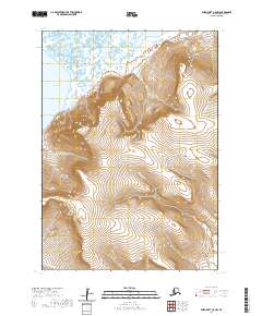
2020 Map of Baird Inlet C-8 NW
USGS Topo · Published 2020About this map
Ukak sits along the western shoreline of this coastal Alaskan landscape, where the tides of Hazen Bay meet a complex network of wetlands and tundra. The terrain is defined by the significant rise of the Kaluyut Mountains in the south and the prominent peak of Erchakrtuk Mtn further north. This 2020 survey illustrates the hydrological character of the Bethel Census Area, tracing the winding paths of the Toksook River and Ikalugtulik River as they drain toward the coast. The distribution of contours around Kaluyut Mtn reveals the sharp contrast between the elevated interior peaks and the expansive, water-saturated lowlands typical of the Yukon-Kuskokwim Delta region. The placement of Isiktok Creek and various unnamed drainages highlights a landscape shaped by seasonal water movement and permafrost-influenced geography.
Find a feature on this map
14 named features on this map. Tap any name to fly to it.
Don’t see what you’re looking for? This feature index may not catch every label — zoom into the map to look around manually.
Map Details
Editions of this 2020 Baird Inlet C-8 NW Map
This is the sole edition of this map. No revisions or reprints were ever made.
Other maps of this area

1951 · Nunivak Island
USGS Topo · 1:250,000

1951 · Baird Inlet
USGS Topo · 1:250,000

1954 · Nunivak Island
USGS Topo · 1:250,000

1954 · Baird Inlet
USGS Topo · 1:250,000

1954 · Baird Inlet C-8
USGS Topo · 1:63,360

1954 · Baird Inlet D-8
USGS Topo · 1:63,360
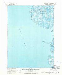
1954 · Nunivak Island D-1
USGS Topo · 1:63,360

1954 · Nunivak Island C-1
USGS Topo · 1:63,360

1958 · Nunivak Island
USGS Topo · 1:250,000

1964 · Nunivak Island
USGS Topo · 1:250,000