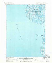
1954 Map of Nunivak Island D-1
USGS Topo · Published 1971About this map
Naskonat Peninsula anchors this coastal survey, where the terrestrial world meets the expansive waters of Hazen Bay. The landscape is defined by its conservation status, notably within the Clarence Rhode National Wildlife Range Area No 1 and the Hazen Bay Migratory Waterfowl Refuge. This coastal region of Alaska showcases a delicate interplay of land and water, with tidal flats labeled as sand and mud stretching across the coastline. Farther south, the Ninglick River flows toward the bay, situated between Kigigak Island and the larger landmass of Nelson Island. Small landmarks like Nunivachak Island provide reference points in the bay, while the absence of roads or established trails highlights the wilderness character of the region during the mid-1950s mapping period.
Find a feature on this map
9 named features on this map. Tap any name to fly to it.
Don’t see what you’re looking for? This feature index may not catch every label — zoom into the map to look around manually.
Map Details
Editions of this 1954 Nunivak Island D-1 Map
This is the sole edition of this map. No revisions or reprints were ever made.
Other maps of this area

1951 · Marshall
USGS Topo · 1:250,000

1951 · Hooper Bay
USGS Topo · 1:250,000

1951 · Nunivak Island
USGS Topo · 1:250,000

1951 · Baird Inlet
USGS Topo · 1:250,000
1952 · Hooper Bay A-2
USGS Topo · 1:63,360

1953 · Hooper Bay
USGS Topo · 1:250,000

1954 · Nunivak Island
USGS Topo · 1:250,000
1954 · Marshall A-8
USGS Topo · 1:63,360

1954 · Marshall
USGS Topo · 1:250,000

1954 · Baird Inlet
USGS Topo · 1:250,000