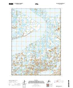
2020 Map of Baird Inlet D-8 SW
USGS Topo · Published 2020About this map
Kigigak Island and the northern reaches of Nelson Island dominate this coastal landscape in the Bethel Census Area. The map depicts a labyrinth of interconnected tidal sloughs and marshlands, illustrating the complex hydrography of the Baird Inlet region. Surveyed as part of the USGS National Geospatial Program, this 2020 edition documents the shifting boundaries of the Alaskan shoreline and the intricate network of wetlands that characterize this maritime environment. The absence of roads or permanent settlements highlights the wilderness nature of the area, where the terrain is primarily defined by the movement of water through the coastal plains and around major landmasses.
Find a feature on this map
6 named features on this map. Tap any name to fly to it.
Don’t see what you’re looking for? This feature index may not catch every label — zoom into the map to look around manually.
Map Details
Editions of this 2020 Baird Inlet D-8 SW Map
This is the sole edition of this map. No revisions or reprints were ever made.
Other maps of this area

1951 · Nunivak Island
USGS Topo · 1:250,000

1951 · Baird Inlet
USGS Topo · 1:250,000

1954 · Nunivak Island
USGS Topo · 1:250,000

1954 · Baird Inlet
USGS Topo · 1:250,000

1954 · Baird Inlet C-8
USGS Topo · 1:63,360

1954 · Baird Inlet D-8
USGS Topo · 1:63,360
1954 · Nunivak Island D-1
USGS Topo · 1:63,360

1954 · Nunivak Island C-1
USGS Topo · 1:63,360

1958 · Nunivak Island
USGS Topo · 1:250,000

1964 · Nunivak Island
USGS Topo · 1:250,000