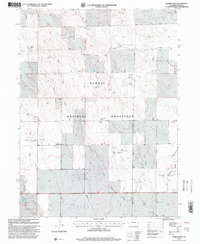
1997 Map of Baker Draw
USGS Topo · Published 2000About this map
The Pawnee National Grassland dominates this portion of Weld County, revealing a landscape defined by water management and ranching infrastructure in the late 20th century. This area, updated by the Forest Service, is characterized by a dense network of windmills that serve as vital landmarks for navigation and land use, including the Stone Coral Windmill and the curiously named Missile Windmill. The drainage patterns of Little Sand Draw and Little Sand Creek flow through the high plains, feeding into localized catchments such as Sand Res No 1 and Sand Res No 2. These small reservoirs and named water features like Howard Reservoir illustrate the essential engineering required to sustain activity in this arid environment. The map provides a precise look at the distribution of named windmills, from the Murphy Windmill to the Kavr Windmill, which often denote historical family grazing allotments or specific camp locations within the national grassland.
Find a feature on this map
25 named features on this map. Tap any name to fly to it.
Don’t see what you’re looking for? This feature index may not catch every label — zoom into the map to look around manually.
Map Details
Editions of this 1997 Baker Draw Map
This is the sole edition of this map. No revisions or reprints were ever made.
Other maps of this area

1908 · Eaton
USGS Topo · 1:125,000

1910 · Eaton
USGS Topo · 1:125,000

1954 · Greeley
USGS Topo · 1:250,000

1957 · Greeley
USGS Topo · 1:250,000

1958 · Greeley
USGS Topo · 1:250,000

1960 · Purcell
USGS Topo · 1:24,000
1960 · Galeton
USGS Topo · 1:24,000

1961 · Greeley
USGS Topo · 1:250,000

1964 · Greeley
USGS Topo · 1:250,000

1965 · Greeley
USGS Topo · 1:250,000