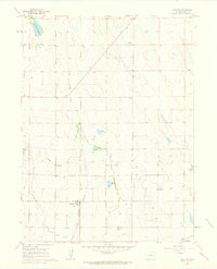
1960 Map of Galeton
USGS Topo · Published 1962About this map
Galeton serves as the primary focal point of this 1960s agricultural landscape, situated at the junction of the Union Pacific railroad. The terrain is defined by an intricate network of irrigation systems and water storage essential for high-plains farming, including the extensive Eaton Ditch and Greeley No 2 Ditch. These man-made waterways connect a series of small basins such as Mason Reservoir, Allison Reservoir, and Owl Creek Reservoir in the north. The presence of an Old Railroad Grade cutting across the northern sections provides a clear view of earlier transportation corridors that once supported the region's development. Beyond the settled area, the map records industrial and navigational markers like a Radio Tower and the VABM Dewey 4904 geodetic marker, reflecting the area's mid-century role in both communication and surveying.
Find a feature on this map
17 named features on this map. Tap any name to fly to it.
Don’t see what you’re looking for? This feature index may not catch every label — zoom into the map to look around manually.
Map Details
Editions of this 1960 Galeton Map
3 editions found
Other maps of this area

1902 · Greeley
USGS Topo · 1:125,000

1908 · Eaton
USGS Topo · 1:125,000

1910 · Eaton
USGS Topo · 1:125,000

1950 · Greeley
USGS Topo · 1:24,000

1950 · Kersey
USGS Topo · 1:24,000

1950 · Barnesville
USGS Topo · 1:24,000

1954 · Greeley
USGS Topo · 1:250,000

1957 · Greeley
USGS Topo · 1:250,000

1958 · Greeley
USGS Topo · 1:250,000

1960 · Purcell
USGS Topo · 1:24,000