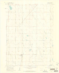
1960 Map of Galeton
USGS Topo · Published 1962About this map
Galeton serves as the primary hub of this Weld County landscape, situated at the intersection of agricultural water management and transport history. The town is anchored by the Union Pacific railroad, which runs alongside an extensive network of irrigation infrastructure including the Eaton Ditch and the Greeley No 2 Ditch. These waterways transformed the high plains into a productive farming region, supported by numerous storage bodies such as Owl Creek Reservoir, Cole Reservoir, and Allison Reservoir. A notable feature for historical researchers is the Old Railroad Grade running northwest through the quadrangle, marking a former path of commerce that predates the 1960 survey. The terrain is further defined by drainage systems like Willow Creek and Owl Creek, with small-scale industrial sites like a Mine and a Sandpit dotting the open country.
Find a feature on this map
19 named features on this map. Tap any name to fly to it.
Don’t see what you’re looking for? This feature index may not catch every label — zoom into the map to look around manually.
Map Details
Editions of this 1960 Galeton Map
3 editions found
Other maps of this area

1902 · Greeley
USGS Topo · 1:125,000

1908 · Eaton
USGS Topo · 1:125,000

1910 · Eaton
USGS Topo · 1:125,000

1950 · Greeley
USGS Topo · 1:24,000

1950 · Kersey
USGS Topo · 1:24,000

1950 · Barnesville
USGS Topo · 1:24,000

1954 · Greeley
USGS Topo · 1:250,000

1957 · Greeley
USGS Topo · 1:250,000

1958 · Greeley
USGS Topo · 1:250,000

1960 · Purcell
USGS Topo · 1:24,000