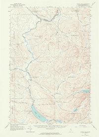
1962 Map of Baker Lake
USGS Topo · Published 1964About this map
Baker Lake serves as the focal point of this Somerset County landscape, which is defined by an intricate network of remote waterways and timberland divisions in the early 1960s. The area is largely structured by the West of the East Line of the State (WELS) township grids, including T 7 R 17 Wels and T 9 R 17 Wels. Human presence is sparse, centered on the Forest Service Camp and a system of primitive Jeep Trails that provided access for forestry management and seasonal use.
Find a feature on this map
27 named features on this map. Tap any name to fly to it.
Don’t see what you’re looking for? This feature index may not catch every label — zoom into the map to look around manually.
Map Details
Editions of this 1962 Baker Lake Map
2 editions found

Other maps of this area

1954 · Baker Lake
USGS Topo · 1:62,500

1954 · Caucomgomoc Lake
USGS Topo · 1:62,500

1954 · Allagash Lake
USGS Topo · 1:62,500

1954 · St. John Pond
USGS Topo · 1:62,500

1954 · Presque Isle
USGS Topo · 1:250,000

1955 · Beaver Pond
USGS Topo · 1:62,500

1955 · Clayton Lake
USGS Topo · 1:62,500

1957 · Norris Brook
USGS Topo · 1:62,500

1957 · Hardwood Mountain
USGS Topo · 1:62,500

1958 · Presque Isle
USGS Topo · 1:250,000