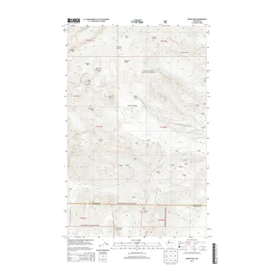
2014 Map of Baker Pass
USGS Topo · Published 2014About this map
Mt Baker and the surrounding glacial terrain dominate this high-altitude landscape within the Mount Baker National Forest. Glacial features such as the Deming Glacier, Easton Glacier, and Metcalfe Moraine define the upper elevations, where the Pacific NW National Scenic Trail traverses the ridges between Baker Pass and Schriebers Meadow. Historical fire lookouts remain perched on notable summits, including Park Butte Lookout and Dock Butte Lookout, providing strategic vantage points across the Whatcom and Skagit County line. Below the ice, the map reveals a network of alpine drainage systems including Rocky Cr and Wanlick Cr, alongside high-country landmarks like the Washington Monument rock formation. The presence of the Railroad Grade label indicates historical engineering efforts to navigate this steep Cascades terrain, while the Schriebers Meadow Trailhead serves as a modern access point for the complex system of divides and meadows that characterize the area.
Find a feature on this map
44 named features on this map. Tap any name to fly to it.
Don’t see what you’re looking for? This feature index may not catch every label — zoom into the map to look around manually.
Map Details
Editions of this 2014 Baker Pass Map
This is the sole edition of this map. No revisions or reprints were ever made.
Other maps of this area

1909 · Mt Baker
USGS Topo · 1:192,000

1915 · Mt. Baker
USGS Topo · 1:250,000

1952 · Lake Shannon
USGS Topo · 1:62,500

1952 · Mt. Baker
USGS Topo · 1:62,500

1952 · Hamilton
USGS Topo · 1:62,500

1953 · Mt Shuksan
USGS Topo · 1:62,500

1955 · Concrete
USGS Topo · 1:250,000

1958 · Concrete
USGS Topo · 1:250,000

1962 · Concrete
USGS Topo · 1:250,000
1973 · Hamilton
USGS Topo · 1:62,500