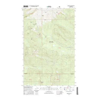
2017 Map of Baker Pass
USGS Topo · Published 2017About this map
Mt Baker dominates the northern landscape of this Cascades survey, where glacial features like the Metcalfe Moraine and Sulphur Moraine trace the movement of ice through the Mount Baker National Forest. A high-altitude network of trails and historic routes defines the area's human imprint, most notably the Railroad Grade and the Pacific NW National Scenic Trail which traverses Baker Pass and Schriebers Meadow. The map detail follows the Whatcom and Skagit County line southward, revealing a complex drainage system where Wanlick Cr, Rocky Cr, and Ridley Cr descend from steep ridges like Forest Divide and Sister Divide. Near the southern border, the Washington Monument landmark and the waters of Springsteen Lake sit below the heights of Dock Butte, illustrating the transition from alpine peaks to forested lake basins.
Find a feature on this map
41 named features on this map. Tap any name to fly to it.
Don’t see what you’re looking for? This feature index may not catch every label — zoom into the map to look around manually.
Map Details
Editions of this 2017 Baker Pass Map
This is the sole edition of this map. No revisions or reprints were ever made.
Other maps of this area

1909 · Mt Baker
USGS Topo · 1:192,000

1915 · Mt. Baker
USGS Topo · 1:250,000

1952 · Lake Shannon
USGS Topo · 1:62,500

1952 · Mt. Baker
USGS Topo · 1:62,500

1952 · Hamilton
USGS Topo · 1:62,500

1953 · Mt Shuksan
USGS Topo · 1:62,500

1955 · Concrete
USGS Topo · 1:250,000

1958 · Concrete
USGS Topo · 1:250,000

1962 · Concrete
USGS Topo · 1:250,000
1973 · Hamilton
USGS Topo · 1:62,500