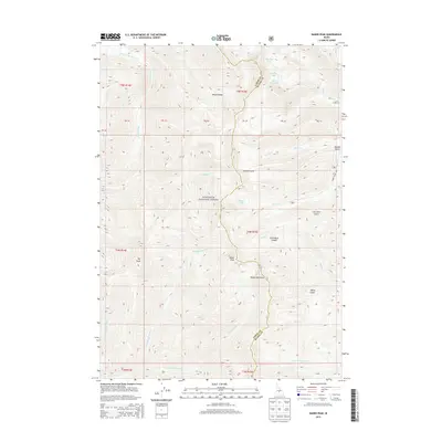
2013 Map of Baker Peak
USGS Topo · Published 2013About this map
The Sawtooth National Forest dominates this high-elevation terrain along the border of Camas and Blaine Counties. Defined by the crests of the Smoky Mountains, the landscape is a network of sharp drainages and prominent summits, including Big Peak and Baker Peak. Water is a central element of the topography, with numerous high-country lakes such as Big Lost Lake, Smoky Lake, and Baker Lake feeding into complex creek systems. Notable watercourses include the W Fork Big Smoky Cr and the Left Fork Placer Cr. The physical geography is further shaped by dramatic features like Royal Gorge and Slide Rock Canyon, alongside local landmarks such as Brodie Gulch and Lost Shirt Gulch. The road network is sparse, centered primarily on Baker Creek Rd, reflecting the wilderness character of this mountain region.
Find a feature on this map
34 named features on this map. Tap any name to fly to it.
Don’t see what you’re looking for? This feature index may not catch every label — zoom into the map to look around manually.
Map Details
Editions of this 2013 Baker Peak Map
This is the sole edition of this map. No revisions or reprints were ever made.
Other maps of this area

1900 · Sawtooth
USGS Topo · 1:125,000

1955 · Hailey
USGS Topo · 1:250,000

1959 · Hailey
USGS Topo · 1:250,000

1962 · Hailey
USGS Topo · 1:250,000

1964 · Frenchman Creek
USGS Topo · 1:24,000

1970 · Sydney Butte
USGS Topo · 1:24,000

1970 · Paradise Peak
USGS Topo · 1:24,000
1970 · Easley Hot Springs
USGS Topo · 1:24,000

1970 · Dollarhide Mtn
USGS Topo · 1:24,000
1970 · Galena
USGS Topo · 1:24,000