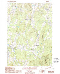
1986 Map of Bakersfield
USGS Topo · Published 1987About this map
Bakersfield and the surrounding township appear as a network of crossroads and agricultural valleys in the mid-1980s. The landscape is defined by the drainage of Black Creek and the Tyler Branch, with smaller tributaries like Beaver Meadow Brook cutting through the upland terrain. Local industry and historical settlement patterns are visible at Gilberts Tannery and through several small cemeteries tucked into the hillsides. Uplands such as Butternut Ridge and Giddings Hill dominate the central topography, while the boundary between Franklin and Lamoille Counties marks the southeastern reach near Shattuck Mtn. This survey captures the transition from small-scale rural hamlets like Bordoville and East Fairfield toward a more modern residential character, while maintaining the distinct ridge-and-valley structure of northern Vermont.
Find a feature on this map
26 named features on this map. Tap any name to fly to it.
Don’t see what you’re looking for? This feature index may not catch every label — zoom into the map to look around manually.
Map Details
Editions of this 1986 Bakersfield Map
This is the sole edition of this map. No revisions or reprints were ever made.
Other maps of this area

1919 · Montgomery
USGS Topo · 1:62,500

1920 · Franklin Pond
USGS Topo · 1:62,500

1920 · Montgomery
USGS Topo · 1:62,500

1922 · Enosburg Falls
USGS Topo · 1:48,000

1924 · Enosburg Falls
USGS Topo · 1:62,500

1925 · Jay Peak
USGS Topo · 1:62,500

1925 · Mount Mansfield
USGS Topo · 1:48,000

1927 · Mount Mansfield
USGS Topo · 1:62,500

1927 · Hyde Park
USGS Topo · 1:48,000

1930 · Hyde Park
USGS Topo · 1:62,500