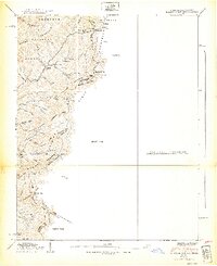
1939 Map of Baldwin Gap
USGS Topo · Published 1939About this map
Stone Mountain and Willen Mountain define the high-elevation divide where the Tennessee and North Carolina borders meet in 1938. The Tennessee Valley Authority mapped this high country during a time when remote mountain communities were still anchored by small country schools and churches. Deep in the hollows and along the ridges, life centered around points like Hammon Chapel and the Laurel Springs Sch, while the Tennessee Valley Divide separated the drainage of the South Fork from the North Fork. The map reveals a settlement pattern of isolated farmsteads and family landmarks, including the Payne Cem near Hemlock and the Wallace Cem to the south. Much of the northern terrain is managed as part of the Cherokee National Forest, highlighting the intersection of federal land management and traditional Appalachian mountain life in the late 1930s.
Find a feature on this map
59 named features on this map. Tap any name to fly to it.
Don’t see what you’re looking for? This feature index may not catch every label — zoom into the map to look around manually.
Map Details
Editions of this 1939 Baldwin Gap Map
2 editions found
Other maps of this area

1891 · Abingdon
USGS Topo · 1:125,000

1893 · Cranberry
USGS Topo · 1:125,000

1894 · Abingdon
USGS Topo · 1:125,000

1895 · Cranberry
USGS Topo · 1:125,000

1899 · Cranberry
USGS Topo · 1:125,000

1902 · Cranberry
USGS Topo · 1:125,000

1909 · Abingdon
USGS Topo · 1:96,000

1911 · Abingdon
USGS Topo · 1:125,000

1935 · Grayson
USGS Topo · 1:24,000

1935 · Park
USGS Topo · 1:24,000