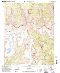
2001 Map of Baldy Cinco
USGS Topo · Published 2005About this map
Snow Mesa dominates the western half of this high-altitude landscape, where the Continental Divide winds past the prominent peak of Baldy Cinco. This 2001 revision illustrates a complex intersection of administrative and natural boundaries, including the Gunnison National Forest, Rio Grande National Forest, and the protected La Garita Wilderness. The high country is defined by steep drainages like Rough Creek and Cebolla Creek, which have shaped the rugged access routes used for generations.
Find a feature on this map
30 named features on this map. Tap any name to fly to it.
Don’t see what you’re looking for? This feature index may not catch every label — zoom into the map to look around manually.
Map Details
Editions of this 2001 Baldy Cinco Map
This is the sole edition of this map. No revisions or reprints were ever made.
Other maps of this area

1905 · San Cristobal
USGS Topo · 1:125,000

1907 · San Cristobal
USGS Topo · 1:125,000

1908 · Uncompahgre
USGS Topo · 1:125,000

1911 · Uncompahgre
USGS Topo · 1:125,000

1914 · Creede
USGS Topo · 1:125,000

1916 · Creede
USGS Topo · 1:125,000

1945 · Durango
USGS Topo · 1:250,000

1953 · Durango
USGS Topo · 1:250,000

1954 · Durango
USGS Topo · 1:250,000

1956 · Montrose
USGS Topo · 1:250,000