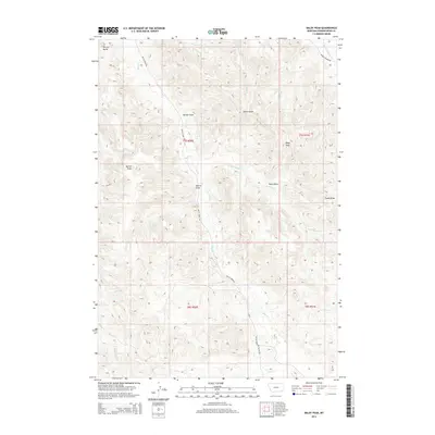
2014 Map of Baldy Peak
USGS Topo · Published 2014About this map
Baldy Peak and Terrett Butte anchor this high-plains landscape in Powder River County, where a network of ephemeral drainage draws and creeks defines the local geography. The map reveals a remote ranching territory characterized by long-established landmarks like Allison Draw and Marvin Draw, which follow the natural contours of the Montana breaks. Transportation is limited to rugged backcountry routes such as Butte Creek Rd and Baking Powder Rd, reflecting the sparse settlement patterns of this cattle country in the early 21st century.
Find a feature on this map
19 named features on this map. Tap any name to fly to it.
Don’t see what you’re looking for? This feature index may not catch every label — zoom into the map to look around manually.
Map Details
Editions of this 2014 Baldy Peak Map
This is the sole edition of this map. No revisions or reprints were ever made.
Other maps of this area

1954 · Ekalaka
USGS Topo · 1:250,000

1956 · Ekalaka
USGS Topo · 1:250,000

1958 · Ekalaka
USGS Topo · 1:250,000

1965 · Ekalaka
USGS Topo · 1:250,000

1970 · Wild Bill Creek
USGS Topo · 1:24,000

1970 · Baldy Peak
USGS Topo · 1:24,000

1970 · Huckins School
USGS Topo · 1:24,000
1970 · Bay Horse
USGS Topo · 1:24,000

1970 · Bear Skull Mountain
USGS Topo · 1:24,000
1970 · Three Bar Ranch
USGS Topo · 1:24,000