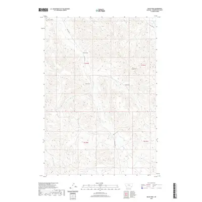
2020 Map of Baldy Peak
USGS Topo · Published 2020About this map
Baldy Peak and Terrett Butte anchor a remote landscape of the Powder River Basin in this 2020 survey. The terrain is defined by a complex network of ephemeral drainage systems and draws, such as Allison Draw and Marvin Draw, which carve through the high plains. Waterways including Butte Cr, Ernest Cr, and the uniquely named Baking Powder Cr weave through the township and range lines of the eastern Montana rangeland. The presence of routes like Butte Creek Rd and Baking Powder Rd provides modern access points into these vast ranching territories. This map offers researchers a precise view of the geographic isolation and topographical character of the Big Horn area, showing how the land is segmented by both natural landmarks like Tracks Draw and the administrative grid of t7s r50e and t7s r51e.
Find a feature on this map
21 named features on this map. Tap any name to fly to it.
Don’t see what you’re looking for? This feature index may not catch every label — zoom into the map to look around manually.
Map Details
Editions of this 2020 Baldy Peak Map
This is the sole edition of this map. No revisions or reprints were ever made.
Other maps of this area

1954 · Ekalaka
USGS Topo · 1:250,000

1956 · Ekalaka
USGS Topo · 1:250,000

1958 · Ekalaka
USGS Topo · 1:250,000

1965 · Ekalaka
USGS Topo · 1:250,000

1970 · Wild Bill Creek
USGS Topo · 1:24,000

1970 · Baldy Peak
USGS Topo · 1:24,000

1970 · Huckins School
USGS Topo · 1:24,000
1970 · Bay Horse
USGS Topo · 1:24,000

1970 · Bear Skull Mountain
USGS Topo · 1:24,000
1970 · Three Bar Ranch
USGS Topo · 1:24,000