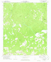
1973 Map of Ball Ground East
USGS Topo · Published 1975About this map
Ball Ground and its eastern surroundings in Cherokee County are defined by the winding course of the Etowah River and its numerous tributaries. In the early 1970s, the landscape remained predominantly rural, dotted with small communities like Mica, Ophir, and Orange. Local spiritual life is well-documented through scattered landmarks such as Shiloh Ch, Conn Creek Ch, and Crystal Springs Ch.
Find a feature on this map
36 named features on this map. Tap any name to fly to it.
Don’t see what you’re looking for? This feature index may not catch every label — zoom into the map to look around manually.
Map Details
Editions of this 1973 Ball Ground East Map
2 editions found

Other maps of this area

1890 · Suwanee
USGS Topo · 1:125,000

1894 · Suwanee
USGS Topo · 1:125,000

1926 · Tate
USGS Topo · 1:62,500

1928 · Tate
USGS Topo · 1:62,500

1955 · Rome
USGS Topo · 1:250,000

1956 · Birmingham
USGS Topo · 1:24,000

1958 · Rome
USGS Topo · 1:250,000

1961 · Rome
USGS Topo · 1:250,000
1961 · Canton
USGS Topo · 1:24,000

1963 · Rome
USGS Topo · 1:250,000