
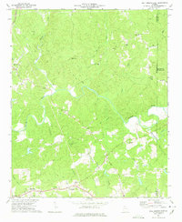
1973 Map of Ball Ground East
USGS Topo · Published 1986About this map
The Etowah River carves a deep valley through this portion of Cherokee County, creating a rugged landscape where numerous small communities and country churches took root. The settlement of Ball Ground occupies the western edge, served by the Seaboard railroad line, while rural hamlets like Mica, Ophir, and Orange are scattered across the higher ground to the east. The map reveals a spiritual and social network defined by local landmarks such as Cherry Grove Ch, Shiloh Ch, and Liberty Ch. Waterways including Long Swamp Creek, Settingdown Creek, and Cane Creek feed into the Etowah, shaping the agricultural and residential patterns of the era. A prominent Quarry near the northern border and an Athletic Field in the south indicate the varied industrial and community life present during the early 1970s.
Find a feature on this map
37 named features on this map. Tap any name to fly to it.
Don’t see what you’re looking for? This feature index may not catch every label — zoom into the map to look around manually.
Map Details
Editions of this 1973 Ball Ground East Map
2 editions found
Other maps of this area

1890 · Suwanee
USGS Topo · 1:125,000

1894 · Suwanee
USGS Topo · 1:125,000

1926 · Tate
USGS Topo · 1:62,500

1928 · Tate
USGS Topo · 1:62,500

1955 · Rome
USGS Topo · 1:250,000

1956 · Birmingham
USGS Topo · 1:24,000

1958 · Rome
USGS Topo · 1:250,000

1961 · Rome
USGS Topo · 1:250,000
1961 · Canton
USGS Topo · 1:24,000

1963 · Rome
USGS Topo · 1:250,000