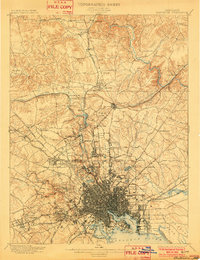
1899 Map of Baltimore
USGS Topo · Published 1902About this map
The inner harbor and surrounding industrial landscape of Baltimore City anchor this turn-of-the-century survey, revealing a port city defined by its deep-water access and complex rail network. Prominent landmarks such as Fort Mc. Henry and Lazaretto Point guard the entrance to the North West Harbor, while the dense grid of the urban center gives way to expanding streetcar suburbs. To the north, the terrain rises into the Bare Hills and through the estates of Towson, where the Northern Central Railroad and the Maryland & Pennsylvania R. R. follow the valley of Jones Falls. This era captures the city's reliance on local water sources like Druid Lake, Clifton Lake, and Lake Roland. Beyond the city limits, the landscape remains largely rural, dotted with substantial institutions like the Sheppard Asylum and industrial sites including the Marble Quarries near Cockeysville.
Find a feature on this map
116 named features on this map. Tap any name to fly to it.
Don’t see what you’re looking for? This feature index may not catch every label — zoom into the map to look around manually.
Map Details
Editions of this 1899 Baltimore Map
2 editions found

Other maps of this area

1892 · Laurel
USGS Topo · 1:62,500

1892 · Ellicott
USGS Topo · 1:62,500

1893 · North Point
USGS Topo · 1:62,500

1893 · Gunpowder
USGS Topo · 1:62,500

1894 · Ellicott
USGS Topo · 1:62,500

1894 · Laurel
USGS Topo · 1:62,500

1894 · Baltimore
USGS Topo · 1:62,500

1894 · Relay
USGS Topo · 1:62,500

1897 · Laurel
USGS Topo · 1:62,500

1898 · Tolchester
USGS Topo · 1:125,000