1898 Map of Tolchester
USGS Topo · Published 1898About this map
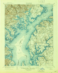
Gunpowder Falls and Little Gunpowder Falls converge near the ancient port site of Joppa, illustrating the complex maritime geography of the upper Chesapeake Bay in the late nineteenth century. The landscape is defined by its deep reliance on water transport and the burgeoning rail corridors of the Philadelphia Baltimore and Washington R.R. and the Baltimore and Ohio R.R.. Numerous landings and wharves, such as Buck Neck Landing and Harris Wharf, dot the shoreline, serving as critical transit points for goods before the expansion of modern road networks.
Find a feature on this map
244 named features on this map. Tap any name to fly to it.
Don’t see what you’re looking for? This feature index may not catch every label — zoom into the map to look around manually.
Map Details
Editions of this 1898 Tolchester Map
This is the sole edition of this map. No revisions or reprints were ever made.
Historical Maps of Essex Through Time
3 maps found