
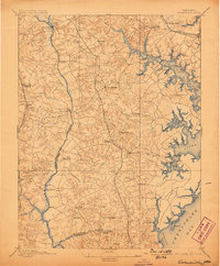
1895 Map of Owensville
USGS Topo · Published 1895About this map
The Patuxent River and the jagged western shoreline of Chesapeake Bay define this landscape south of Annapolis during the late nineteenth century. The interior is characterized by a high density of small rural settlements such as Davidsonville, Owensville, and Lothian, many of which were connected by the Proposed Drum Point Railroad route cutting through the center of the county. This planned line reflects the era's ambition to link the tobacco-growing regions of Anne Arundel and Calvert counties more directly to the deep-water ports. Along the bay, maritime activity is evident at West River (Galesville) and Fairhaven, where the numerous creeks like Glebe Creek and Whitemarsh Creek provided vital access for commerce and local travel. Further inland, the map captures the transition from agriculture to early infrastructure at the Annapolis Water Works and important crossing points like Priest Bridge and Governor Bridge.
Find a feature on this map
63 named features on this map. Tap any name to fly to it.
Don’t see what you’re looking for? This feature index may not catch every label — zoom into the map to look around manually.
Map Details
Editions of this 1895 Owensville Map
2 editions found
Other maps of this area

1892 · Laurel
USGS Topo · 1:62,500

1892 · Prince Frederick
USGS Topo · 1:62,500

1892 · Brandywine
USGS Topo · 1:62,500

1892 · Owensville
USGS Topo · 1:62,500

1892 · Annapolis
USGS Topo · 1:62,500

1893 · Sharps Island
USGS Topo · 1:62,500

1893 · North Point
USGS Topo · 1:62,500

1894 · Laurel
USGS Topo · 1:62,500

1894 · Relay
USGS Topo · 1:62,500

1895 · Prince Frederick
USGS Topo · 1:62,500