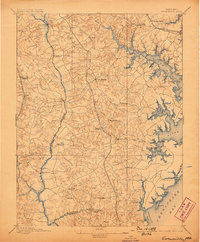
1895 Map of Owensville
USGS Topo · Published 1898About this map
Patuxent River crossings and the intricate shoreline of the Chesapeake Bay define this landscape at the close of the nineteenth century. Several historic river crossings, including Priest Bridge, Governor Bridge, and Hills Bridge, facilitate travel across the western county line between Prince George and Anne Arundel. To the east, the tidewater geography of the South River, Rhode River, and West River shows a maritime-focused economy, where settlements like Owensville and Davidsonville serve as central inland hubs.
Find a feature on this map
61 named features on this map. Tap any name to fly to it.
Don’t see what you’re looking for? This feature index may not catch every label — zoom into the map to look around manually.
Map Details
Editions of this 1895 Owensville Map
2 editions found

Other maps of this area

1892 · Laurel
USGS Topo · 1:62,500

1892 · Prince Frederick
USGS Topo · 1:62,500

1892 · Brandywine
USGS Topo · 1:62,500

1892 · Owensville
USGS Topo · 1:62,500

1892 · Annapolis
USGS Topo · 1:62,500

1893 · Sharps Island
USGS Topo · 1:62,500

1893 · North Point
USGS Topo · 1:62,500

1894 · Laurel
USGS Topo · 1:62,500

1894 · Relay
USGS Topo · 1:62,500

1895 · Prince Frederick
USGS Topo · 1:62,500