
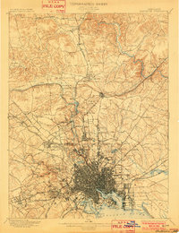
1899 Map of Baltimore
USGS Topo · Published 1899About this map
Fort McHenry stands as a sentinel at the mouth of the North West Harbor, anchoring a city at a moment of transition. The city's dense gridiron streets give way to suburban developments like Roland Park and Waverly, while the north is defined by the industrial extraction of the Marble Quarries near Cockeysville and Texas. This landscape is heavily shaped by an early transit network, with the Electric R.R. and several turnpikes, including the York Turnpike and Harford Turnpike, radiating from the center.
Find a feature on this map
109 named features on this map. Tap any name to fly to it.
Don’t see what you’re looking for? This feature index may not catch every label — zoom into the map to look around manually.
Map Details
Editions of this 1899 Baltimore Map
2 editions found
Other maps of this area

1892 · Laurel
USGS Topo · 1:62,500

1892 · Ellicott
USGS Topo · 1:62,500

1893 · North Point
USGS Topo · 1:62,500

1893 · Gunpowder
USGS Topo · 1:62,500

1894 · Ellicott
USGS Topo · 1:62,500

1894 · Laurel
USGS Topo · 1:62,500

1894 · Baltimore
USGS Topo · 1:62,500

1894 · Relay
USGS Topo · 1:62,500

1897 · Laurel
USGS Topo · 1:62,500

1898 · Tolchester
USGS Topo · 1:125,000