1948 Map of Baltimore
USGS Topo · Published 1950About this map
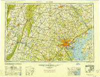
Baltimore serves as the central hub for this mid-century regional survey, which illustrates the complex intersection of maritime commerce, heavy industry, and military infrastructure during the early Cold War era. The sprawling industrial waterfront at Sparrows Point and the established defenses at Fort McHenry underscore the city's strategic importance along the Chesapeake Bay. Major transit corridors like the Pennsylvania RR and Baltimore & Ohio RR connect the coast to inland centers including Frederick, York, and the historic site of Gettysburg.
Find a feature on this map
243 named features on this map. Tap any name to fly to it.
Don’t see what you’re looking for? This feature index may not catch every label — zoom into the map to look around manually.
Map Details
Editions of this 1948 Baltimore Map
2 editions found

Other maps of this area

1884 · Harpers Ferry
USGS Topo · 1:125,000

1890 · Mt. Vernon
USGS Topo · 1:125,000

1891 · Harpers Ferry
USGS Topo · 1:125,000

1891 · Mt. Vernon
USGS Topo · 1:125,000

1892 · Laurel
USGS Topo · 1:62,500

1892 · Ellicott
USGS Topo · 1:62,500

1892 · Owensville
USGS Topo · 1:62,500

1892 · Annapolis
USGS Topo · 1:62,500

1893 · North Point
USGS Topo · 1:62,500

1893 · Gunpowder
USGS Topo · 1:62,500