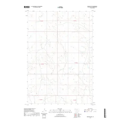
2017 Map of Bams Butte NW
USGS Topo · Published 2017About this map
High plains drainage patterns define the landscape of Harding County in this 2017 survey. The terrain is dominated by the seasonal paths of Clarks Fork Cr in the northwest and Double X Cr, which winds through the eastern sections of the quadrangle. These watercourses reflect the arid character of the region, where subtle elevation changes dictate the flow of runoff across the open range. Goose Cr further marks the southern reaches, highlighting the essential role these creek beds play in the local topography. Human presence is sparse, represented primarily by the linear path of J B Rd, a local connector that cuts across the township boundaries of t17n r5e and t17n r6e. The map provides a clear view of the Public Land Survey System grid, illustrating the systematic division of this remote section of South Dakota.
Find a feature on this map
10 named features on this map. Tap any name to fly to it.
Don’t see what you’re looking for? This feature index may not catch every label — zoom into the map to look around manually.
Map Details
Editions of this 2017 Bams Butte NW Map
This is the sole edition of this map. No revisions or reprints were ever made.
Other maps of this area

1935 · Reva
USGS Topo · 1:125,000

1935 · Hoover
USGS Topo · 1:125,000

1935 · Harding
USGS Topo · 1:125,000

1935 · Buffalo
USGS Topo · 1:125,000

1954 · Lemmon
USGS Topo · 1:250,000

1957 · Lemmon
USGS Topo · 1:250,000

1971 · Buffalo
USGS Topo · 1:24,000
1971 · Sheep Pen Draw SW
USGS Topo · 1:24,000
1971 · Sheep Pen Draw SE
USGS Topo · 1:24,000

1973 · Redig
USGS Topo · 1:24,000