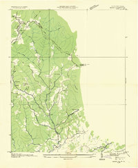
1934 Map of Bandy
USGS Topo · Published 1934About this map
Stone Steps Ridge and Whitaker Ridge define the rugged topography along the Virginia and West Virginia border in this 1934 field examination. The landscape is deeply incised by the drainage of Indian Creek and its various branches, where narrow valleys dictate the placement of local settlements and infrastructure. Small mountain communities like Bandy and Harman are linked by the Norfolk and Western railroad and early mountain trails, reflecting the area's isolation and reliance on rail for transport.
Find a feature on this map
33 named features on this map. Tap any name to fly to it.
Don’t see what you’re looking for? This feature index may not catch every label — zoom into the map to look around manually.
Map Details
Editions of this 1934 Bandy Map
This is the sole edition of this map. No revisions or reprints were ever made.
Other maps of this area

1891 · Tazewell
USGS Topo · 1:125,000

1895 · Tazewell
USGS Topo · 1:125,000

1897 · Tazewell
USGS Topo · 1:125,000

1910 · Iaeger
USGS Topo · 1:48,000

1912 · Pounding Mill
USGS Topo · 1:62,500

1912 · Iaeger
USGS Topo · 1:62,500

1912 · Welch
USGS Topo · 1:62,500

1914 · Iaeger
USGS Topo · 1:48,000

1915 · Richlands
USGS Topo · 1:48,000

1916 · Pounding Mill
USGS Topo · 1:62,500