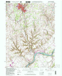
1997 Map of Bangor
USGS Topo · Published 1999About this map
Martins Creek and its namesake junction define the industrial and residential landscape of this Northampton County region during the late twentieth century. The density of slate quarrying and stone extraction is evident near Bangor and Pen Argyl, where numerous quarries dot the terrain alongside a network of Conrail rail lines that supported the local economy. Educational and spiritual foundations of these communities are well-documented, from Bangor High Sch and Roosevelt Sch to Kingdom Hall Ch.
Find a feature on this map
51 named features on this map. Tap any name to fly to it.
Don’t see what you’re looking for? This feature index may not catch every label — zoom into the map to look around manually.
Map Details
Editions of this 1997 Bangor Map
This is the sole edition of this map. No revisions or reprints were ever made.
Other maps of this area

1890 · Easton
USGS Topo · 1:62,500

1891 · Easton
USGS Topo · 1:62,500

1891 · Delaware Water Gap
USGS Topo · 1:62,500

1893 · Delaware Water Gap
USGS Topo · 1:62,500

1894 · Allentown
USGS Topo · 1:62,500

1914 · Wind Gap
USGS Topo · 1:62,500

1916 · Wind Gap
USGS Topo · 1:62,500

1932 · Easton
USGS Topo · 1:62,500

1936 · Delaware Water Gap
USGS Topo · 1:48,000

1939 · Allentown
USGS Topo · 1:62,500