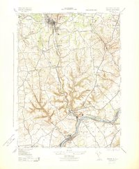
1943 Map of Bangor
USGS Topo · Published 1943About this map
Old Bangor Slate Quarry and various cement works dominate the landscape of the Mount Bethel and Washington townships during the Second World War. The heavy industrial footprint of the Alpha Cement Co and the prominent Lehigh Cement Co Stack near Martins Creek reflect the era's intense production requirements. Transportation networks are densely packed here, with the Pennsylvania and Lehigh and New England railroads tracing the valleys to serve these mineral extraction sites.
Find a feature on this map
56 named features on this map. Tap any name to fly to it.
Don’t see what you’re looking for? This feature index may not catch every label — zoom into the map to look around manually.
Map Details
Editions of this 1943 Bangor Map
This is the sole edition of this map. No revisions or reprints were ever made.
Other maps of this area

1890 · Easton
USGS Topo · 1:62,500

1891 · Easton
USGS Topo · 1:62,500

1891 · Delaware Water Gap
USGS Topo · 1:62,500

1893 · Delaware Water Gap
USGS Topo · 1:62,500

1894 · Allentown
USGS Topo · 1:62,500

1914 · Wind Gap
USGS Topo · 1:62,500

1916 · Wind Gap
USGS Topo · 1:62,500

1932 · Easton
USGS Topo · 1:62,500

1936 · Delaware Water Gap
USGS Topo · 1:48,000

1939 · Allentown
USGS Topo · 1:62,500