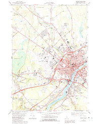
1978 Map of Bangor
USGS Topo · Published 1992About this map
The Penobscot River serves as the central artery for this late 1970s survey, dividing the bustling urban centers of Bangor and Brewer. The city of Bangor is shown in high detail, from the massive footprint of the Bangor International Airport to the concentrated medical and educational district featuring Eastern Maine Medical Center and Husson College. A network of smaller settlements including West Bangor, East Bangor, and North Bangor surrounds the city core, while the Maine Central Railroad converges at Northern Maine Junction, illustrating the area's role as a major regional transit hub.
Find a feature on this map
118 named features on this map. Tap any name to fly to it.
Don’t see what you’re looking for? This feature index may not catch every label — zoom into the map to look around manually.
Map Details
Editions of this 1978 Bangor Map
2 editions found
Other maps of this area

1900 · Orland
USGS Topo · 1:62,500

1900 · Bucksport
USGS Topo · 1:62,500

1902 · Orono
USGS Topo · 1:62,500

1902 · Bucksport
USGS Topo · 1:62,500

1902 · Bangor
USGS Topo · 1:62,500

1942 · Orland
USGS Topo · 1:62,500

1942 · Bangor
USGS Topo · 1:62,500

1942 · Bucksport
USGS Topo · 1:62,500

1944 · Orono
USGS Topo · 1:62,500

1946 · Bangor
USGS Topo · 1:62,500