
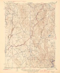
1944 Map of Bangor
USGS Topo · Published 1944About this map
Gold mining operations and timber interests define this 1941 landscape at the intersection of Butte and Yuba counties. The foothills are deeply etched by the intricate drainage of North Honcut Creek and South Honcut Creek, where extraction sites like the Blue Lead Mine and Central Pacific Mine highlight the region's industrial heritage. Small communities such as Bangor and Hansonville are mapped alongside rural schoolhouses, including Kings Sch and Peoria Sch, which once anchored these remote settlements.
Find a feature on this map
49 named features on this map. Tap any name to fly to it.
Don’t see what you’re looking for? This feature index may not catch every label — zoom into the map to look around manually.
Map Details
Editions of this 1944 Bangor Map
2 editions found
Other maps of this area

1888 · Marysville
USGS Topo · 1:125,000

1888 · Smartsville
USGS Topo · 1:125,000

1888 · Bidwell Bar
USGS Topo · 1:125,000

1891 · Bidwell Bar
USGS Topo · 1:125,000

1891 · Chico
USGS Topo · 1:125,000

1891 · Marysville
USGS Topo · 1:125,000

1891 · Smartsville
USGS Topo · 1:125,000

1892 · Smartsville
USGS Topo · 1:125,000

1893 · Chico
USGS Topo · 1:125,000

1893 · Bidwell Bar
USGS Topo · 1:125,000