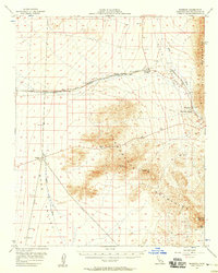
1956 Map of Bannock
USGS Topo · Published 1958About this map
The Atchison Topeka and Santa Fe Railway cuts a prominent path through this desert corridor, connecting small rail-side outposts like Bannock and Homer. The map illustrates the region's reliance on fixed infrastructure and sparse water sources, such as the Sacramento Springs and various wells. Overland travel follows established routes including the Old Trails Road and Santa Fe Road, which navigate the arid terrain of Piute Valley and the Sacramento Mountains. Evidence of early prospecting and utility development appears through scattered prospects and a long-distance Pipeline, while high points like Eagle Peak and the Dead Mountains frame the eastern edge of the Mojave landscape. This survey captures a specific network of desert navigation and logistics prior to the expansion of modern highway systems.
Find a feature on this map
38 named features on this map. Tap any name to fly to it.
Don’t see what you’re looking for? This feature index may not catch every label — zoom into the map to look around manually.
Map Details
Editions of this 1956 Bannock Map
2 editions found
Other maps of this area

1886 · Camp Mohave
USGS Topo · 1:250,000

1892 · Camp Mohave
USGS Topo · 1:250,000

1903 · Needles
USGS Topo · 1:125,000

1904 · Needles Special
USGS Topo · 1:125,000

1910 · Ivanpah
USGS Topo · 1:250,000

1912 · Ivanpah
USGS Topo · 1:250,000

1926 · Mohave City
USGS Topo · 1:96,000

1942 · Camp Mohave
USGS Topo · 1:250,000

1942 · Ivanpah
USGS Topo · 1:250,000

1942 · Amboy
USGS Topo · 1:250,000